Pearl Riverkeeper
  • Home
  • About Us
    • Our Watershed
    • Our Team
    • Our Programs
    • Year in Review
  • Our River
    • Water Testing Results
    • Watershed Issues
    • Watershed Research
    • Water Trail
    • Water Watch
  • GET INVOLVED
    • Support our Programs
    • Clean our Watershed
    • Test our Water
    • Mark our Storm Drains
  • NEWS
    • 2022 Clean Sweep Results
    • PRESS
    • Blog
    • Resources
  • REPORT POLLUTION
GULF STURGEON
Picture
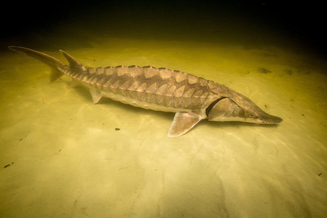
Photo credit: Ryan Hagerty, USFWS
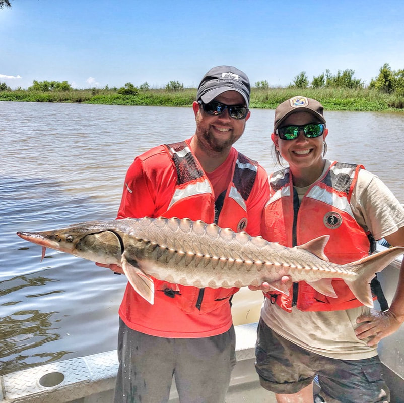
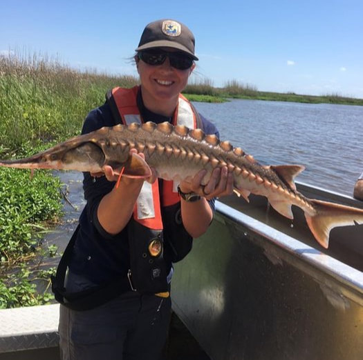
The Gulf Sturgeon is one of 7 federally-listed "threatened" species that are part of the Pearl River Basin ecosystem. This fish, often called a "Living Dinosaur", can live for over 60 years, grow to 9 feet and can weigh up to 300 pounds. The Pearl River is designated "Critical Habitat" for this threatened species that migrates seasonally up and down the river. Gulf sturgeon move from the Gulf of Mexico into coastal rivers in early spring and spawning occurs in the upper reaches of these rivers. Dams such as the sills at Pools Bluff and Jackson Waterworks block this species' passage to its historical spawning habitats. Current threats include habitat loss due to the construction of dams and sills which impede the ability of the species to migrate to spawning areas in the spring.  
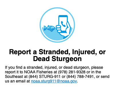
In the spring, our endangered Gulf sturgeon begin migrating up the Pearl River for spawning. Last year, sturgeon were seen as far north as the confluence of the Pearl and the Strong Rivers and the Jackson Waterworks dam. Keep an eye out for these magnificent creatures and, if you spot one, please contact the sturgeon hotline at 1-844-STURG911.

Sturgeon are federally protected in the Southeast and it is illegal to harm or impede them.
Picture

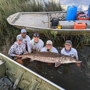
PEARL RIVER GULF STURGEON STUDIES 
NOAA Gulf Spill Restoration project to "Characterize Gulf sturgeon spawning habitat, habitat use, and origins of juvenile sturgeon in the Pearl and Pascagoula River systems." ​
  • Objective:  "1100-3600 Gulf sturgeon were exposed to oil during the BP oil spill, causing immune system suppression, genetic changes and mortality. This $2.5 million dollar study will gather data on sturgeon migration patterns in the Pearl and Pascagoula, enabling prioritization of habitat restoration projects such as in-stream barrier removal (Bogue Chitto and Bogalusa sills), spawning reef creation and riparian restoration. This project could have far-reaching benefits for the general health of the Pearl and for the revival of this iconic endangered species." NOAA Gulf Spill Restoration
  • Funding:  NOAA Gulf Spill Restoration​
  • Read more here: www.gulfspillrestoration.noaa.gov/sites/default/files/2019-03%20OO%20TIG%20Final%20RPEA1%20FINAL.pdf

Acoustic receivers, tagging and telemetry
Picture
  • Objective:  tagging and tracking juvenile and subadult sturgeon in the Pearl and Pascagoula River.  Acoustic receivers in the Pearl River have been placed at strategic locations from Jackson south to below the sills at Pool's Bluff in LA to track fish movements.
  • Funding: USFWS (Panama City)
  • Project team members: Dr. Michael Andres lab at University of Southern Mississippi.  
  • Photo: The University of Southern Mississippi graduate students and research technicians hold an adult Gulf sturgeon captured in the Pascagoula River. Pictured from left to right: Elizabeth Greenheck, Alfonso Cohuo, Austin Draper, Kasea Price, and Kati Wright. (Photo credit: Michael Andres, The University of Southern Mississippi)

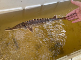
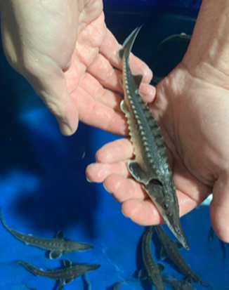
Juvenile sturgeon assessment
Picture
  • Objective:  In the spring of 2020 Louisiana State University in partnership with USFWS began conducting acoustic telemetry and capture-recapture surveys to assess juvenile Gulf Sturgeon population dynamics, habitat use, and movement. This study follows three years of research on juvenile Gulf Sturgeon conducted by the USFWS Baton Rouge Fish and Wildlife Conservation Office. The objectives of this research are to define habitat use and within-river movements of Gulf Sturgeon in the lower Pearl River. Additionally, this research provides samples for genetic analysis and age estimation along with capture and movement data to our partners working under the NRDA Gulf Sturgeon Monitoring and Adaptive Management Project. This information will provide insight into genetic relatedness among river systems, overwinter survival, and estimated abundance of juvenile Gulf Sturgeon in the Pearl River. 
    In addition to this overall project, research by LSU is focusing on movements and habitat affinities of tagged Gulf Sturgeon during their freshwater residency. Gulf Sturgeon are often found in deep river bends, however there is little published research on the specific environmental factors that drive Gulf Sturgeon to occupy these areas. For her master’s thesis, Amanda Popovich is investigating the effects of habitat variables such as water depth, river curvature, woody debris accumulation, temperature, salinity, and flow on the location of Gulf Sturgeon and their movement between different habitat types. So far, 136 Gulf Sturgeon have been captured for this study. Of those 136 individuals, 35 have been fitted with acoustic transmitters that can be picked up by an acoustic receiver array in the lower Pearl River.  Information from detections of these fish will be used to inform Gulf Sturgeon occupancy and develop a Habitat Suitability Index to inform future Gulf Sturgeon conservation efforts.
  • Funding: NOAA National Resource Damage Assessment (NRDA)
  • Project team members: Dr. Bill Kelso (LSU), Amanda Popovich (LSU) with boat support from USFWS (Baton Rouge)
  • Photo: Amanda Popovich

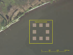
Gulf oyster habitat restoration 
Picture
  • Objective:  investigate methods for optimizing oyster habitat restoration in the Gulf of Mexico which would ultimately lead to oyster population recovery and enhancement of ecosystem services in coastal waters. A secondary objective is to evaluate whether the creation of oyster reefs as part of coastal restoration activities has any impacts on the use of critical habitat by Gulf sturgeon.
  • Project team members:  The U.S. Army Engineer Research and Development Center (ERDC) (Dr. Todd Slack and Dr. Safra Altman) in collaboration with the University of Southern Mississippi (Dr. Michael Andres), the University of Kentucky and MS Department of Marine Resources (MDMR)
  • More info: www.usm.edu/news/2021/release/erdc-usm-reestablish-gulf-reefs.php​

Side scan sonar habitat mapping
Picture
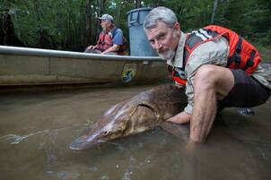
Photo: Dr. Adam Kaeser, USFWS
  • Objective:  Using side scan sonar to conduct feature mapping of the length of the Pearl River to estimate the availability of potential Gulf sturgeon spawning habit in the river.  ​
  • Project team members: Dr. Adam Kaeser from USFWS (Panama City).  Data processing by a North Arizona University PhD student in Flagstaff, AZ. 

Microchemistry Fin Ray Samples
Picture
  • Objective:  At present, the Gulf sturgeon is in severe decline due to damming, dredging, habitat degradation, and climate change. In 1995, the Gulf Sturgeon Recovery Plan was implemented to prevent further reduction of populations with a goal of removing this species from the endangered list by 2023. Our project is using microchemistry techniques on pectoral fin spines collected non-lethally from 200 juvenile Gulf sturgeon. This technique uses the chemistry of the fin spine, which reflects the water chemistry, to assess the life history of the fish. Locations within the river system of different individuals will be identified as well as potential spawning regions of the Pearl and Pascagoula River systems. In sturgeons, the leading pectoral fin spine is analyzed because it can be removed non-lethally. Collecting sturgeon fin spines has previously been demonstrated to be a useful tool to determine spatial patterns of habitat use and movement of juvenile Gulf sturgeon. The insight gained from these techniques will be important for fisheries management and guiding restoration of the sturgeon population. Findings will be used to help government agencies such as US Fish and Wildlife Service, Mississippi Department of Wildlife, Fisheries and Parks and Louisiana Department of Wildlife and Fisheries help protect these areas, guide restoration efforts, and protect the future of Gulf sturgeon.
  • Project team members : Dr. Peter Allen, Joshua Neary, Dr. Rinat Gabitov and Dr. Michael Colvin (MSU Department of Wildlife, Fisheries and Aquaculture) and Dr. Brenda Pracheil (Oak Ridge National Laboratory, Tennessee)

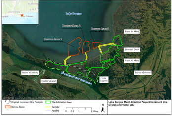
Lake Borgne Marsh Recovery Project
Picture
  • Objective:  create approximately 2,816 acres of new marsh habitat along the southern margin of Lake Borgne, which has been degraded due to sea-level rise, high subsidence rates, diminished sediment supply, and extreme storm events.  Project will also use telemetry surveillance to determine whether acoustically tagged gulf sturgeon use the southern portion of Lake Borgne.
  • Funding: NOAA Gulf Spill Restoration 
  • Project team members:  Deepwater Horizon (DWH) Louisiana Trustee Implementation Group (TIG), Coastal Protection and Restoration Authority (CPRA) of Louisiana, USFWS, LDWF, NOAA
  • Read more: www.gulfspillrestoration.noaa.gov/sites/default/files/Final_MAMPlan_LakeBorgne_092120_508.pdf​

USFWS (Baton Rouge) Acoustic Tagging 
Picture
Picture
  • Objective: summer sampling for juvenile Gulf sturgeon on the lower Pearl River. The sturgeon captured are tagged and released and will help biologist estimate the population size for this Threatened species. 
  • Funding: USFWS
  • ​Research labs:  Project lead Glenn Constant (USFWS) and Kayla Kimmel (USFWS).   

GULF STURGEON HABITAT
Picture
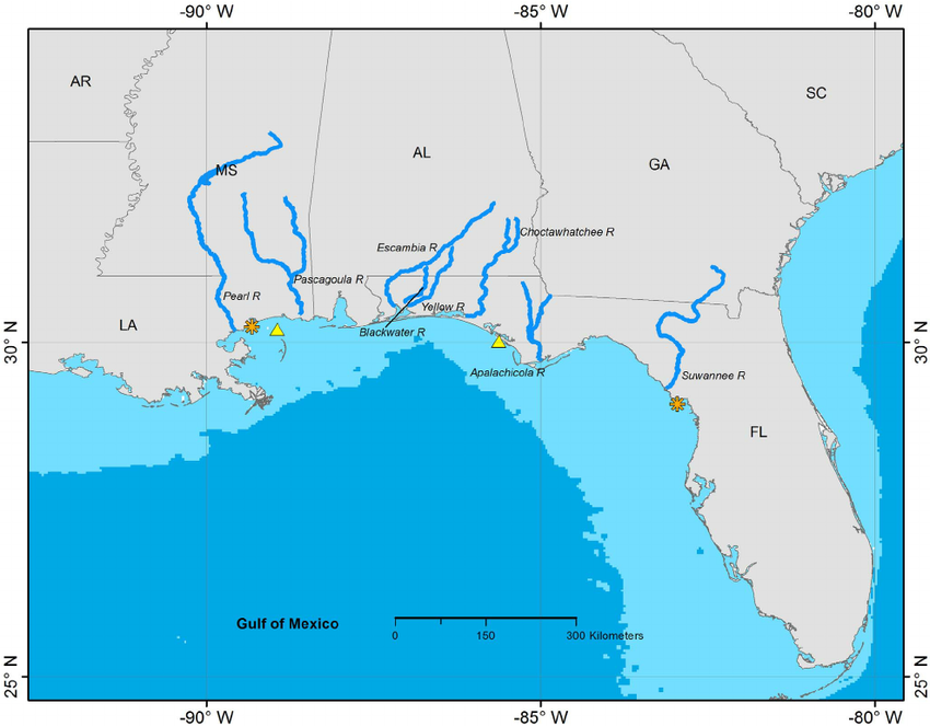
"Documented distribution of Gulf Sturgeon in North America, determined from acoustic and archival telemetry projects. The orange asterisks mark the easternmost and westernmost locations of confirmed detections of acoustic-tagged Gulf Sturgeon. Gulf Sturgeon spawn in coastal rivers including the eight shown on this map. Spawning and non-spawning Gulf Sturgeon typically remain in coastal rivers until fall and occupy estuarine and nearshore marine waters during winter. Yellow triangles indicate winter concentration areas for Gulf Sturgeon from two or more river systems. The 100 m isobath is shown as the light blue areas near the coast. doi:10.1371/journal.pone.0071552.g002" 

Source: https://www.researchgate.net/.../Documented-distribution...
Ready to support our work for Clean Water and Healthy Rivers?
BECOME A MEMBER!
CONTACT US

    Stay Informed!  Sign up to receive the latest news.

Subscribe to Newsletter

Pearl Riverkeeper is a licensed member of the Waterkeeper Alliance, the largest and fastest growing nonprofit solely focused on clean water. 

Picture
  • Home
  • About Us
    • Our Watershed
    • Our Team
    • Our Programs
    • Year in Review
  • Our River
    • Water Testing Results
    • Watershed Issues
    • Watershed Research
    • Water Trail
    • Water Watch
  • GET INVOLVED
    • Support our Programs
    • Clean our Watershed
    • Test our Water
    • Mark our Storm Drains
  • NEWS
    • 2022 Clean Sweep Results
    • PRESS
    • Blog
    • Resources
  • REPORT POLLUTION