Upper Pearl River Water Trail
Have you paddled the Pearl? CONTACT PEARL RIVERKEEPER with paddling route submissions, edits, suggestions or any other relevant information for our Water Trail in progress. Thank you!
SECTION 1. Burnside Lake Water Park (Pearl River Boatway Park**, Hwy 15 Landing, Philadelphia, MS)
DESCRIPTION: "Burnside Lake Water Park consists of 115 acres in Neshoba County approximately 5 miles northeast of Philadelphia on Highway 15. The park is located on Burnside Lake, an oxbow lake of the Pearl River. The park facilities include: The Park Auditorium that can accommodate meetings of up to 180 people in heated and air conditioned comfort 22 improved campsites with water and electricity, boat ramp, oxbow lake, fishing pier, 3 open-air pavilions, 3 lighted ball fields, picnicking areas, playgrounds, nature trail, suspension bridge, bathhouse and comfort stations. Burnside Lake Water Park is operated and maintained by the Philadelphia Neshoba County Park Commission. 601-656-7621" Neshoba County
SECTION 2. Highway 15 to Highway 19, 2.5 miles
SECTION 3. Highway 19 to Highway 16 at Edinburg, 20 miles.
SECTION 4. Highway 16 to ramp at Battle Bluff Road, 8 miles. "The Battle Bluff ramp is located on a small road northwest of bridge, just south of the Sunrise community off Highway 16."*
SECTION 5. Ramp at Battle Bluff Rd to South Carthage Landing (Hwy 35), 10 miles. "The Carthage ramp is accessible from the southeast side of the bridge."*
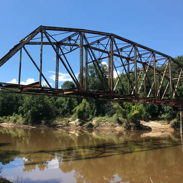
SECTION 6. South Carthage Landing (Hwy 35) to Old Highway 13 Bridge, just east of Highway 25, 10 miles. "The Old Hwy 13 Bridge is closed, but a ramp is located on the southeast side."*
|
SECTION 7. Old Highway 13 Bridge ramp to Leake County Water Park (1190 Park Rd, Lena, MS), 10 miles. "There's also a ramp on the southeast side of the lowhead dam a half mile farther. Both the Water Park and the lowhead dam are located west of Highway 25 on the south side of the river."* More information
PUT IN: Old Highway 13 Bridge LAUNCH/LANDING: Concrete boat ramp DESCRIPTION: No facilities TAKE OUT: Leake County Water Park (1190 Park Rd, Lena, MS) LAUNCH/LANDING: Concrete boat ramp DESCRIPTION: Leake County Water Park has a pool, trails, a playground, boat ramp, covered pavilion, picnic tables, grills, bathhouse and RV sites with full hookups. |
|
SECTION 8. Leake County Water Park (1190 Park Rd, Lena, MS) ramp to ramp at Low Head Dam (1190 Park Rd, Lena, MS), .5 miles.
Use extreme caution at the Low Head Dam. This dam is not navigable by boat. Leake County Water Park has a pool, trails, a playground, boat ramp, covered pavilion, picnic tables, grills, bathhouse and RV sites with full hookups. Beginner Tip: Leake County Water Park area is perfect for the beginner paddler. You can paddle the creeks without having to enter the main stem of the Pearl River. Avoid the Low Head Dam. |
|
|
SECTION 9. Low Head Dam to Coal Bluff Campground (1319 Coal Bluff Rd, Lena, MS), 4.5 miles
PUT IN: Low Head Dam (1190 Park Rd, Lena, MS) LAUNCH/LANDING: Concrete boat ramp DESCRIPTION: No facilities. Use extreme caution at the Low Head Dam. This dam is not navigable by boat. TAKE OUT: Coal Bluff Campground (1190 Park Rd, Lena, MS) LAUNCH/LANDING: Concrete boat ramp DESCRIPTION: Coal Bluff Campground offers camping pads, swimming pool, playground, tennis courts, bathhouse, laundry, pavilion, nature trail, boat launch, RV sites with full hookups and primitive camping areas. |
|
|
SECTION 10. Coal Bluff Campground to Ratliff Ferry, 7 miles
PUT IN: Coal Bluff Campground (1319 Coal Bluff Rd, Lena, MS) LAUNCH/LANDING: Concrete boat ramp DESCRIPTION: Coal Bluff Campground offers camping pads, swimming pool, playground, tennis courts, bathhouse, laundry, pavilion, nature trail, boat launch, RV sites with full hookups and primitive camping areas. TAKE OUT: Ratliff Ferry (1275 Ratliff Ferry Rd, Canton, MS) LAUNCH/LANDING: DESCRIPTION: Beginner Tip: Paddle the river north from Coal Bluff Campground and float back down. Beautiful scenery, wildlife and bird watching. |
*Water trail information from Herndon, Ernest. Canoeing Mississippi. Jackson: University Press of Mississippi, 2001.
**The 9 "Pearl River Boatway Parks" listed here were created through a cooperative effort by the Pearl River Basin Development District, county governments, U.S. Department of the Interior, National Park Service, Land and Water Conservation Fund, and the Mississippi Department of Wildlife, Fisheries and Parks. These Water Parks stretch from Neshoba County to the Gulf Coast and provide access to the Pearl River as well as its tributaries, the Strong, Bogue Chitto, Jourdan Rivers and Magees Creek. The Water Parks, currently managed by the local county Parks Commissions, provide recreational opportunities over total of 981 acres in the Pearl River Watershed.
**The 9 "Pearl River Boatway Parks" listed here were created through a cooperative effort by the Pearl River Basin Development District, county governments, U.S. Department of the Interior, National Park Service, Land and Water Conservation Fund, and the Mississippi Department of Wildlife, Fisheries and Parks. These Water Parks stretch from Neshoba County to the Gulf Coast and provide access to the Pearl River as well as its tributaries, the Strong, Bogue Chitto, Jourdan Rivers and Magees Creek. The Water Parks, currently managed by the local county Parks Commissions, provide recreational opportunities over total of 981 acres in the Pearl River Watershed.


