
Flash Flooding, Tributary Flooding, and River Flooding
Flash Flooding
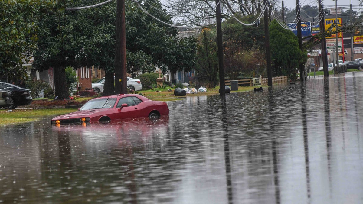
Clarion Ledger, 1/14/2020
|
Flash flooding is caused by heavy or excessive rainfall occurring over a short period of time, leading to torrents of water running through streets, neighborhoods, and storm drains. Flash flooding is very dangerous because it combines the destructive power of a flood with incredible speed.
Flash flooding occurs when heavy rainfall exceeds the ability of the ground to absorb it. Urban areas are especially prone to flash flooding because their impervious surfaces like large parking lots, streets and buildings do not allow water to infiltrate the ground, causing the water to run off to the low spots very quickly. In addition to causing a flood hazard, excessive stormwater runoff carries trash, debris and pollutants to our waterways, reducing water quality. |
Tributary Flooding
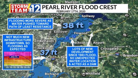
River Flooding
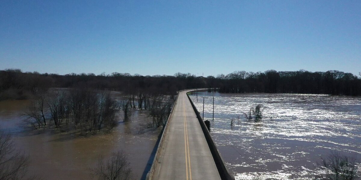 Drone video captures the bloated Pearl River. (Source: WLBT) February 16, 2020
|
In 1964, in an effort to rein in the Pearl River at Jackson, the Army Corps of Engineers began construction on a 1.5 mile levee on the Jackson side of the river, a 10.3 mile levee on the Rankin side, along with 2.1 miles of river straightening and channelization. At that time, the Jackson Daily News reported that the project would: "....mark the end of devastating (sic) floods which almost annually have inundated thousands of acres, forced hundreds from their home, and threatened to destroy major industries vital to the economy of both Rankin and Hinds counties." President of the Levee Board stated in the Clarion Ledger that, "(T)his project will make many many acres of valuable land secure for home, business and industrial use" and the USACE projected that, "(T)here is no reason why the project should not give indefinite protection from flooding in the area".
|
1964 Levee system, Jackson, MS
|
What followed was a frenzy of public and private development in the flood plains of Hinds and Rankin county, with Jackson zoning its entire flood plain for residential, commercial and industrial uses. New highways, bridges, shopping centers, a new water treatment plant, the Coliseum, fairgrounds, electrical substations and homes were all built in the newly "protected" and secure flood plain.
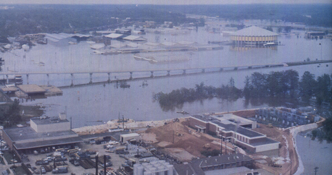
1979 Easter Flood, Entergy archives
|
Less than a decade later, in April 1979, the City of Jackson and surrounding counties were hit with the flood of record, devastating communities and causing an estimated $500-$700 million in damages. Thousands of homes and businesses in the Jackson area were inundated in the flood stage that lasted from 10 to 14 days in some areas. After the Easter flood, Congress authorized the Army Corps of Engineers to develop a comprehensive flood control plan for the Jackson metropolitan area.
|
Since 1979, numerous Pearl River flood control plans have been introduced. Originally, flood control plans, such as the Shoccoe Dry Dam Plan authorized by Congress in 1986, and the Comprehensive Levee Plan proposed by the Army Corps of Engineers in 1996, focused solely on flood control. Later, flood control plans developed by local sponsors attempted to leverage economic development opportunities along with flood control, starting with the Two Lakes Plan in 1996, and followed by the LeFleur Lakes Plan, the Lower Lake Plan and the One Lake Project.
In 2007, Rankin-Hinds Pearl River Flood and Drainage Control District (also known as the Levee Board) accepted the role of "local sponsor", taking over responsibility for planning and executing flood control projects in the Jackson area. In 2013, the Levee Board held "scoping meetings" in Slidell, LA and Jackson, MS, and began writing a Feasibility and Draft Environmental Impact Report (DEIS). Their DEIS, released in 2018, included their preferred "One Lake" plan of widening, deepening and straightening 10 miles of the river. In July 2022, after completing a public comment period and technical review process, the Levee Board submitted their plan to the US Army Corps of Engineers (USACE). In Oct. 2022, the Assistant Secretary of the Army (Civil Works) charged the USACE with "completing the data gaps" in Levee Board's feasibility study to inform the ASA(CW) final determinations and decision. The USACE DEIS is scheduled for release in 2023.
In 2007, Rankin-Hinds Pearl River Flood and Drainage Control District (also known as the Levee Board) accepted the role of "local sponsor", taking over responsibility for planning and executing flood control projects in the Jackson area. In 2013, the Levee Board held "scoping meetings" in Slidell, LA and Jackson, MS, and began writing a Feasibility and Draft Environmental Impact Report (DEIS). Their DEIS, released in 2018, included their preferred "One Lake" plan of widening, deepening and straightening 10 miles of the river. In July 2022, after completing a public comment period and technical review process, the Levee Board submitted their plan to the US Army Corps of Engineers (USACE). In Oct. 2022, the Assistant Secretary of the Army (Civil Works) charged the USACE with "completing the data gaps" in Levee Board's feasibility study to inform the ASA(CW) final determinations and decision. The USACE DEIS is scheduled for release in 2023.
|
City of Jackson Pearl River Flood Stages:
Minor: 28 feet Moderate: 33' Major: 36' (Flooding begins to impact homes in NE Jackson when the river reaches 36.2') 1979 "flood of record": 43.28' May 1983: 39.58' Feb 2020: 36.8' Aug 2022: 35.37' April 2003: 35.25' |
|
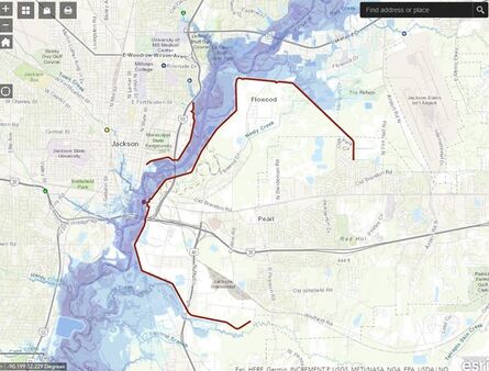
During the Feb 2020 major flood event, proactive and deft management of the Ross Barnett Spillway by the Pearl River Valley Water Supply District and its state/federal partners allowed the Pearl River to crest lower than originally forecast. Still, significant damage occurred in the City of Jackson and in downriver communities. The federal disaster declaration for the February 10-18 flood event covered 14 counties: Attala, Carroll, Claiborne, Clay, Copiah, Grenada, Hinds, Holmes, Issaquena, Leflore, Marion, Sharkey, Warren and Yazoo. These counties sustained significant damage to public buildings, private homes, highways and roads.
Jackson and surrounding counties desperately need a flood risk management solution, including a moratorium on any continued construction in flood-prone areas.
Jackson and surrounding counties desperately need a flood risk management solution, including a moratorium on any continued construction in flood-prone areas.