
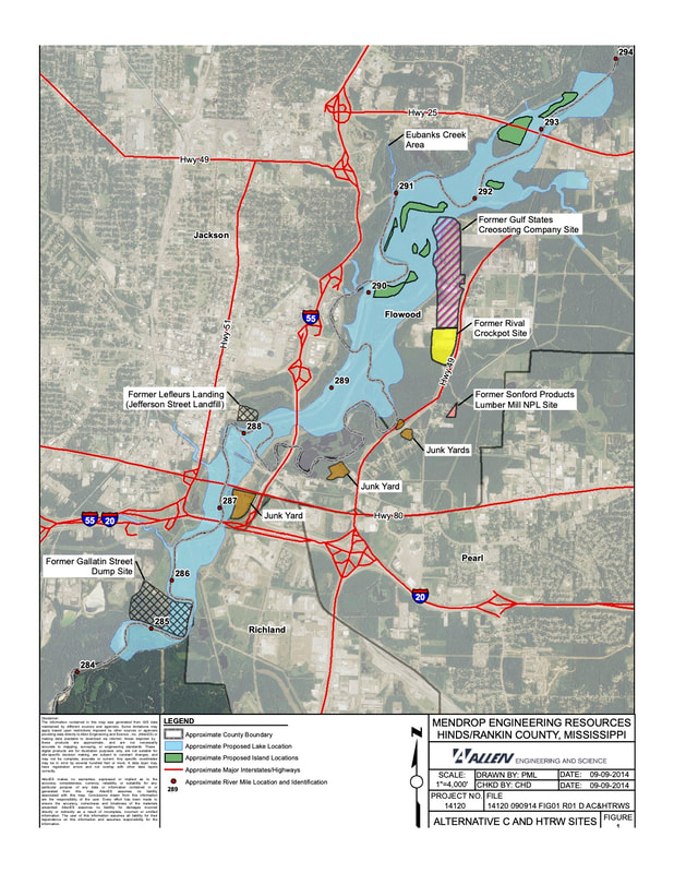
Hazardous Toxic Waste Sites in One Lake project area
The 2018 Draft Environmental Impact Statement (DEIS) identified 3 Hazardous Toxic Radiological Waste (HTRW) Sites in the "One Lake" (Alternative C) project area and stated that the environmental impacts associated with their remediation could include, “the temporary addition of large additions of sediment to the Pearl River, the release or exacerbation of current releases of leachate and/or solid and hazardous substances to the groundwater and/or surface water...” The HTRW sites identified are the Gulf States Creosote Company Site, LeFleurs Landing Site (Jefferson St Landfill), and the Gallatin St Dump Site.
Click to view full report
|
|
The Rankin Hinds Pearl River Flood and Drainage Control District must remediate all 3 Hazardous Toxic Waste Sites prior to the USACE beginning any "Lake" construction and has acknowledged "complete financial responsibility for all necessary cleanup and response costs of any hazardous substances regulated under CERCLA that are located in, on, or under lands, or rights-of-way that the federal government determines to be required for construction, operation and maintenance of the project." Final Agency Technical Review, June 2020, comment 8293857 Real Estate
GULF STATES CREOSOTE COMPANY SITE
141-acre site operated as wood treating facility for 25 years. This location was studied by the EPA in 2010 for inclusion in the National Priority List as Superfund site. Sediment samples collected from the oxbow sloughs on the property exhibit elevated creosote levels and creosote can be observed on the surface of the slough waters. The 2018 DEIS states that the creosote residuals occurring in the sediment cover a broad area and that the creosote sloughs "present a continuing source of release of creosote chemicals to the environment and to the City of Jackson's drinking water."
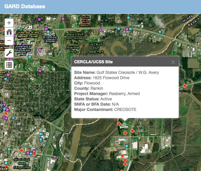
Click to view MDEQ interactive map
"The onsite levee is owned by the Levee Board - which is a joint venture between the state and Rankin County. Mr. John McGowan owns the marsh area due west of the levee. McGowan has plans of developing the marsh areas as residential subdivisions." page 3
"Sediment samples collected from the marsh located west of the Gulf States property exhibited elevated levels of constituents detected in on-site soils and are common constituents used in the wood preserving industry." page 26
"Sediment samples collected from the marsh located west of the Gulf States property exhibited elevated levels of constituents detected in on-site soils and are common constituents used in the wood preserving industry." page 26
"Contaminated soil has been detected throughout the property and comprises approximately 1,441,876 square feet (or 33 acres). Based on analytical results from 2003 and 2006, SVOCs and pesticides including acenaphthylene, anthracene, benzo(a)anthracene, benzo(b)fluoranthene, benzo(ghi)perylene, benzo(k)fluoranthene, benzo(a)pyrene, carbazole, chrysene, dibenzo(a,h)anthracene, fluoranthene, indeno(l,2,3-cd)pyrene, naphthalene, phenanthrene, pyrene, 4,4'-DDE, 4,4'-DDT, endrin, endrin aldehyde, endrin ketone, and methoxychlor were present in the surface soil as a resuU of Gulf States' operations (Refs. 1, 17, 16, 6). Of these contaminants, benzo(b)fluoranthene, benzo(k)fluoranthene, indeno(l,2,3-cd)pyrene, and 4,4'-DDE have migrated to the subsurface soil at elevated concentrations." page 9
"Based on the currently available information, the Gulf States Creosoting site score is 26.8. This score is less than the cutoff value of 28.50 necessary to consider listing a site on the National Priorities List (NPL). EPA will determine the need for further remedial actions at this property." page 14
"Based on the currently available information, the Gulf States Creosoting site score is 26.8. This score is less than the cutoff value of 28.50 necessary to consider listing a site on the National Priorities List (NPL). EPA will determine the need for further remedial actions at this property." page 14
LEFLEURS LANDING SITE (JEFFERSON STREET LANDFILL)
45-acre plot of land where City of Jackson operated an unregulated landfill dating back to early 1900s. No retroactive improvements (e.g. liners, caps, leachate collection systems) were ever installed on the landfill and studies show that groundwater may be currently interacting with debris and leachate at the site. Site Assessments have found Polynuclear Aromatic Hydrocarbons and benzene concentrations above regulatory limits.
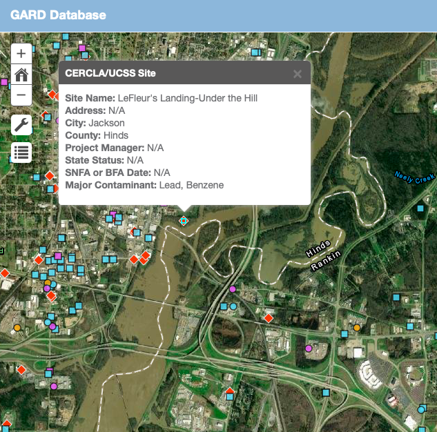
Click to view MDEQ interactive map
"Due to the large area of the former landfill, and the presence of lead concentrations greater than Tier 1 TRGs that are possibly high enough to be classified as hazardous wastes, excavation of the area is not considered a viable option." page 35
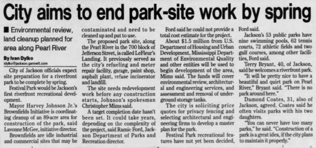
Clarion-Ledger, 10 Jul 2003
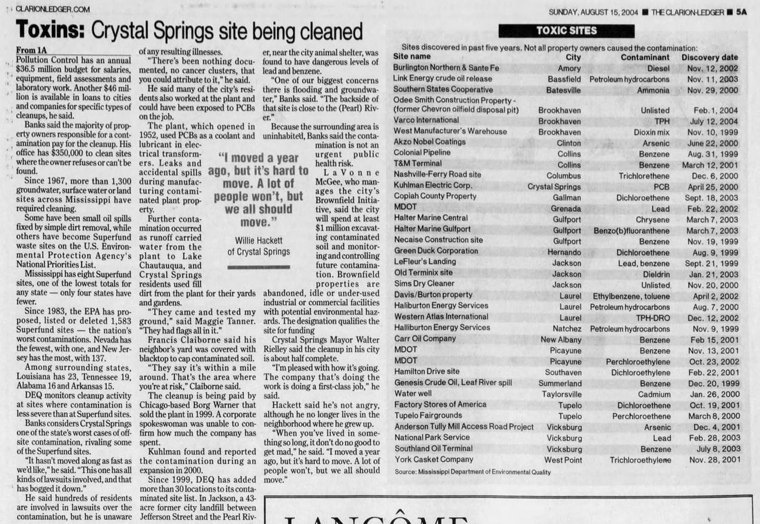
Clarion-Ledger, 15 Aug 2004
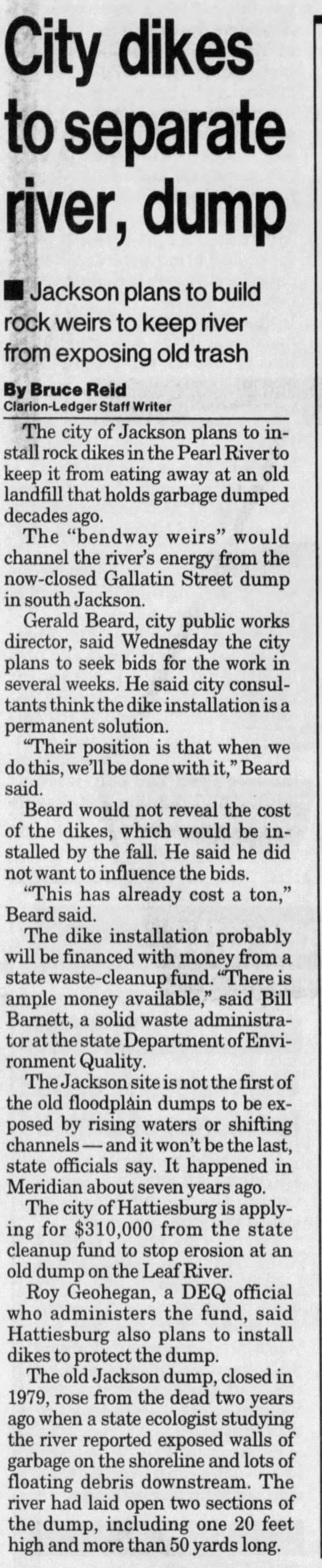
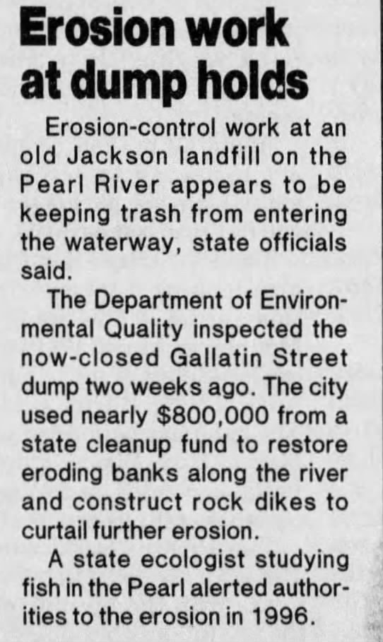
GALLATIN STREET DUMP SITE
117-acre site operated as unpermitted City of Jackson municipal dump for 20 years. Groundwater samples collected from borings placed within the landfill found leachate with concentrations of cadmium, lead, and nickel which were above the Maximum Contaminate Levels (MCLs) established under the Safe Drinking Water Act for these parameters. Visual inspection showed leachate from the landfill seeping out of the soils along the bank of the Pearl River.
117-acre site operated as unpermitted City of Jackson municipal dump for 20 years. Groundwater samples collected from borings placed within the landfill found leachate with concentrations of cadmium, lead, and nickel which were above the Maximum Contaminate Levels (MCLs) established under the Safe Drinking Water Act for these parameters. Visual inspection showed leachate from the landfill seeping out of the soils along the bank of the Pearl River.
Click to view Clarion-Ledger, 7 May 1998
|
Clarion-Ledger, 7 April 1999
|
2018 DEIS Proposed Remedial Actions
"The Creosote Slough would be located within the project area proposed for excavation and dredging for the channel improvement; therefore, the impacted sediments within the Creosote Slough will be evaluated and mitigated. Remedial mitigation alternatives could include, but are not limited to, capping in order to and permanently cover and not disturb the sediments, or excavating and removing the impacted sediments prior to dredging the proposed project."
"The Lefleurs Landing Site would be located along the edge of the proposed channel improvement and would require additional capping and bank stabilization. Further investigations would be necessary to determine potential leaching of landfill waste chemicals to the groundwater and movement of groundwater into the channel improvement. Groundwater controls and a slurry wall may be appropriate remedial actions in this event."
"The channel improvements would also bisect the Gallatin Street Dump Site; therefore, it would require excavation and removal of approximately half of the landfill site to create the proposed project. This material may be incorporated into the current remaining landfill area to further elevate the area, cap the area, and provide bank stabilization. An elevated mound could be created for public access and to provide a public park, boat launch, recreational facilities, and scenic views. Further investigations would be necessary here also to determine potential leaching of landfill wastes to the groundwater and movement of groundwater into the proposed project. Groundwater controls and a slurry wall may be appropriate remedial actions."
page 15, Allen ES HTRW report
*2018 DEIS cost estimate for remediation of all 3 waste sites = $8 million
*2018 DEIS contains no remediation studies or evidence for cost estimates
*All remediation actions must be complete prior to beginning construction of "One Lake"
Impacts of Hazardous Toxic Site Remediation according to 2018 DEIS
- "Construction activities have the potential to increase noise levels, erosion and runoff of silt, generation of air borne dust, and the release of hazardous substances from these HTRW sites."
- "Other immediate effects that may result from construction of the proposed project could include a temporary loss of the secondary water supply intake for the City of Jackson. Jackson utilizes an existing water treatment plant which is located on the Pearl River at a location scheduled for dredging and development of the “Channel Improvement/Weir/Levee” alternative. This water treatment plant is used as a secondary source and backup water supply source for the City. The dredging of sediments and subsurface soils in the Pearl River could potentially increase the turbidity of the surface waters to levels unacceptable for human consumption; therefore, the City of Jackson would need to evaluate temporary water supply alternatives during the duration of dredging and construction activities."
page 16, Allen ES HTRW report