Pearl Riverkeeper
  • Home
  • About Us
    • Our Watershed
    • Our Team
    • Our Programs
    • Year in Review
  • Our River
    • Water Testing Results
    • Watershed Issues
    • Watershed Research
    • Water Trail
    • Water Watch
  • GET INVOLVED
    • Support our Programs
    • Clean our Watershed
    • Test our Water
    • Mark our Storm Drains
  • NEWS
    • 2022 Clean Sweep Results
    • PRESS
    • Blog
    • Resources
  • REPORT POLLUTION

Where is Flood Control for Jackson?

2/19/2020

 
THE BACKSTORY 
The Rankin-Hinds Pearl River Flood and Drainage Control District (Levee Board) was established in response to a 1961 flood and Congressional-authorization for a Rankin and Hinds county federal flood control project.  In 1964, the US Army Corps of Engineers (USACE) began construction on a 1.5 mile levee on the Jackson side of the river, a 10.3 mile levee on the Rankin side, along with 5 miles of river straightening and channelization.  
Picture
The Jackson Daily News reported that the project would: "....mark the end of devastating (sic) floods which almost annually have inundated thousands of acres, forced hundreds from their home, and threatened to destroy major industries vital to the economy of both Rankin and Hinds counties."   President of the Levee Board stated in the Clarion Ledger that, "(T)his project will make many many acres of valuable land secure for home, business and industrial use" and the USACE projected that, "(T)here is no reason why the project should not give indefinite protection from flooding in the area".   What followed was a frenzy of public and private development in the flood plains of Hinds and Rankin county, with Jackson zoning its entire flood plain for residential, commercial and industrial uses.  New highways, bridges, shopping centers, a new water treatment plant, Coliseum, fairgrounds, electrical substations and homes were built in the newly "protected" and secure flood plain.
​ 
​
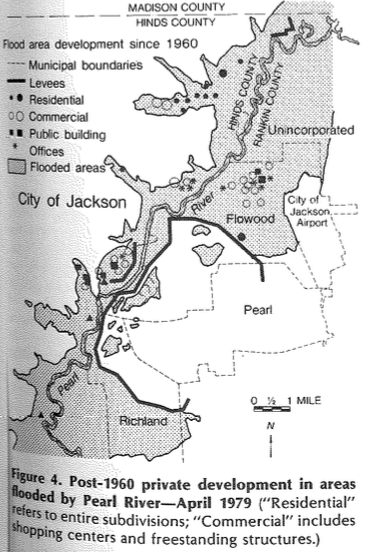
THE JACKSON FLOOD OF 1979
Less than a decade later, in April 1979, the City of Jackson and surrounding counties were hit with the flood of record, devastating communities and causing an estimated $500-$700 million in damages.  Thousands of homes and businesses in the Jackson area were inundated in the flood stage that  lasted from 10 to 14 days in some areas.  Again, Congress gave authorization for the USACE to develop a comprehensive flood control plan for the Jackson metropolitan area.  Now, 41 years after the flood of record, there is still no flood mitigation for the Jackson metro area.  What happened?
​
DEVELOPMENT AS FLOOD CONTROL
Following the 1979 flood, numerous Pearl River flood control plans are developed by the USACE.   In 1996, the USACE Feasibility Report, Flood Control, Pearl River Basin, Jackson Metropolitan Area, Mississippi recommends a system of flood walls and levees for flood control called the Comprehensive Levee Plan.  This plan is ready for implementation and construction in 1996 but does not satisfy the development desires of the Levee Board and local developers.  

​17 years after the 1979 flood, the Levee Board rejects a feasible flood control plan.  
​
​
Picture
​Instead, the Two Lakes Plan is proposed by John McGowan, his oil and gas company, McGowan Working Partners, and other landowners who advocate for the building of two lakes on the Pearl River.  The plan includes dredging and widening the Pearl River channel between the Ross Barnett Reservoir and Richland and the insertion of weirs to create a 4,500-acre upper lake and  a 500-acre lower lake.  The Corps of Engineers estimates that the Two Lake project would cost about $1.5 billion including a $150 million landfill removal.  Citing a cost-benefit analysis of the Two Lake plan, the USACE rejects the project because of its prohibitive cost and insufficient flood control benefits.  
Does the Levee Board give up on their development as flood control projects after that?  Of course not.  
  • 2001- Levee Board adopts the LeFleur Lakes Plan, a flood control and economic development plan similar to John McGowan's Two Lake Plan, but slightly modified.  LeFleurs Lake Development Foundation non-profit receives $99,200 through the Housing and Urban Development Economic Development Initiative Grant for FY 2009, $347,200 through the Housing and Urban Development Neighborhood Initiative Grant for FY 2009, and $345,530 through the Small Business Association Congressional Mandated Award to be used toward the LeFleur Lakes Project for FY 2007. (PEER Report 545)  The $2.85 million budget for the LeFleur Lakes study was to be split by the USACE and the Levee Board.   The Boards of Supervisors of Hinds and Rankin counties agreed to provide the 50% local cost share.
  • 2007- The USACE concludes that the LeFleur Lakes Plan is less effective at flood control than the Comprehensive Levee Plan. 

Does the Levee Board give up on their development as flood control project then?  Of course not.
  • The Levee Board develops the Lower Lake Plan.  The Lower Lake Plan estimates $605 million in upfront costs for levee stabilization, lake construction, property aquisition and core infrastructure with the majority of the costs expected to fall on the public sector". 
  • In July 2007, The Water Resources Development Act (WRDA) authorizes federal expenditure for the Comprehensive Levee Plan or a locally preferred plan. Federal funding participation is limited to the amount necessary to pay the federal share (65%) of the Comprehensive Levee Plan which equals $133,770,000.  The WRDA bill also terminates the USACE agreement with the Levee Board and allows the Levee Board to become the local project sponsor. 

​In 2007, 28 years after the 1979 flood, the Levee Board again rejects the Comprehensive Levee Plan which has USACE approval and also Congressionally-authorized federal expenditure.

  • 2010- A report completed by the Mississippi Legislative PEER Committee documents the Levee Board's failure to develop an adequate flood control plan, stating "Between 1979 and 2010, four Pearl River flood control studies were conducted in order to find a 'politically supportable, implementable flood control solution for the Jackson metropolitan area'.  Combined, the studies cost federal and local taxpayers approximately $7 million.  However, none of the studies options have gained the necessary local and federal support as needed for implementation." (PEER Report 545)​  The report states bluntly that, "The plans incorporating economic development cost more than levees."
Does the Levee Board give up on their development as flood control project then?  Of course not.
​
ENTER THE ONE LAKE PROJECT
  • 2011-John McGowan and other real estate developers form a nonprofit called the Pearl River Vision Foundation to promote a new lake development called the One Lake plan.
  • 2012- The Vision 2022 presentation by the Greater Jackson Chamber Partnership includes the One Lake project as part of its Jackson-area economic development plan.   The Greater Jackson Chamber Partnership donates $200,000 to the Levee Board for the One Lake EIS and feasibility studies.
  • 2013- The Mississippi Development Authority with permission from Governor Phil Bryant, provides the One Lake project with $1 million of Mississippi state funds for the One Lake EIS and feasibility studies.
  • 2017- House Bill 1585 gives the Levee Board authority to tax "property that is directly or indirectly benefited" by a flood control project.  The bill allows the Levee Board authority to decide which land within the district would benefit from the One Lake project and "levy a special improvement assessment" in order to "provide funds for the operation, maintenance and preservation of the project."
  • 2018- An incomplete One Lake project Draft Environmental Impact Statement/Feasibility Report is released to the public with an associated 45 day public comment period.
  • 2020- The One Lake project Environmental Impact Statement/Feasibility Report is sent to the USACE in Washington DC for review. ​
​
PAVE PARADISE AND PUT UP A PARKING LOT
Continued construction in the flood plain since the 1983 flood, the 2nd highest flood on record, made predicting flood stage impacts for the most recent Feb 2020 flood more difficult.  During this high water event, the 3rd highest flood on record, Mike Word, Rankin County Emergency Management Director, stated that, because of development in the decades since the last major flood, "nobody can tell you where the 38-foot mark goes" and how widespread the flooding will be.  He said that the amount of concrete and asphalt and sedimentation built up in the basin area over years will prevent water from soaking into the ground and could exacerbate flooding.  "Nobody knows for sure how much the basin will hold."  (Clarion Ledger, Feb 15, 2020).  Governor Reeves commented at a MEMA press conference on Feb 16, "There were areas, due in large part to construction since 1983, there were areas that were receiving water that we anticipated would not receive water until they were at 38' level.  All of these projections are just projections because, when you think about the amount of construction that's happened, particularly in the Jackson area since 1983, what we find is that there are certain areas where 36' feels like 38' and maybe there are going to be some areas where 38' feels like 39 or 39.5."  ​
Picture
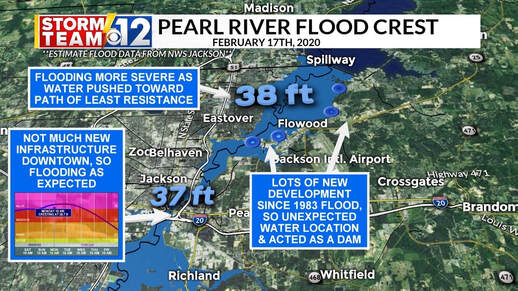
Channel 12 Meteorologist, Jacob Lanier, reported that the Feb 2020 flood impacts differed from the forecasts because, " the flood projection maps we used are almost entirely based on the 1983 flood. Over the past 40 years, Rankin County has vastly changed. Going from mostly farm land to a very urbanized area along Lakeland & Old Fannin. This development, with concrete and landscaping, has made it harder for water to pass through. So it acted as a dam of sorts, pushing flood water up the path of least resistance into Northeast Jackson & Hanging Moss Creek. This turned a 36.7 ft river into a 38 ft river for those neighborhoods."
​

"FLOOD CONTROL" HUBRIS
In an Engineering News-Record article from Feb 2020, Keith Turner, Levee Board attorney, is quoted, "The approach (One Lake) would also widen the river and make way for commercial development."  Sound familiar?  The hubris that their "flood control" project would work and would thus enable us to continue to build more structures in the flood zone.  We've learned nothing since 1961, when a false sense of security created by a "flood control" solution, led to a massive encroachment on the Pearl River flood plain.  Jackson does not need a flood plain development project.  The Jackson-metro area needs levee improvements, levee setbacks to remove the metro-area bottleneck and allow for an expanded flood plain, local green infrastructure projects to control flash flooding combined with local adoption and  enforcement of appropriate restrictions on further floodplain development and select buyouts of properties that continually flood.  As we wait for the Levee Board to push through another misguided Lake plan, construction in Hinds and Rankin county flood zones continues, putting more people and structures at risk for the next high water event.  

    Author

    Pearl Riverkeeper is a licensed member of the Waterkeeper Alliance, the largest and fastest growing nonprofit solely focused on clean water.

    Archives

    September 2022
    July 2022
    March 2022
    February 2022
    January 2022
    April 2021
    July 2020
    May 2020
    February 2020
    September 2019
    August 2019
    July 2019
    June 2019
    May 2019
    April 2019
    January 2019
    December 2018
    November 2018
    September 2018
    July 2018
    June 2018
    May 2018
    November 2017
    September 2017
    August 2017

    Categories

    All

    RSS Feed

Ready to support our work for Clean Water and Healthy Rivers?
BECOME A MEMBER!
CONTACT US

    Stay Informed!  Sign up to receive the latest news.

Subscribe to Newsletter

Pearl Riverkeeper is a licensed member of the Waterkeeper Alliance, the largest and fastest growing nonprofit solely focused on clean water. 

Picture
  • Home
  • About Us
    • Our Watershed
    • Our Team
    • Our Programs
    • Year in Review
  • Our River
    • Water Testing Results
    • Watershed Issues
    • Watershed Research
    • Water Trail
    • Water Watch
  • GET INVOLVED
    • Support our Programs
    • Clean our Watershed
    • Test our Water
    • Mark our Storm Drains
  • NEWS
    • 2022 Clean Sweep Results
    • PRESS
    • Blog
    • Resources
  • REPORT POLLUTION