Alternative C ("One Lake")
Description of Alternative C from 2024 USACE Draft Environmental Impact Statement (DEIS). Page numbers reference the 2024 DEIS Main Report unless otherwise specified.
 2024 USACE DEIS, PDF page 105
Alternative C, the "One Lake" proposed by the Rankin Hinds Pearl River Flood and Drainage Control District was found "not justified" in the 2024 USACE DEIS.
The USACE found that the plan to dredge and widen the Pearl River to build a 2600 acre "Lake" would cost $1-$2.1 billion and would have a negative cost benefit. The "One Lake" plan would also cause flooding for at least 220 structures in the project area and potentially many more south of the project area. Other adverse impacts of the "One Lake" project are listed below.
The USACE found that the plan to dredge and widen the Pearl River to build a 2600 acre "Lake" would cost $1-$2.1 billion and would have a negative cost benefit. The "One Lake" plan would also cause flooding for at least 220 structures in the project area and potentially many more south of the project area. Other adverse impacts of the "One Lake" project are listed below.
Difference between the "One Lake" calculations completed by the Drainage District and the numbers determined by the USACE
2018 DEIS Drainage District calculations for "One Lake" |
2024 DEIS USACE calculations for "One Lake" |
|
Cost Estimate |
Approximately $340 million |
$1-$2.1 billion |
Calculated Lake surface water area |
1,700 acres |
2,562.25 acres |
New slurry wall for levee seepage |
Not included |
1,460 feet |
New pumping stations to address drainage |
Not included |
2 |
Estimated terrestrial habitat mitigation |
5,000 acres |
24,760 acres |
Bridge countermeasures |
Not included |
7 bridges |
Induced flooding |
Not defined |
220+ structures |
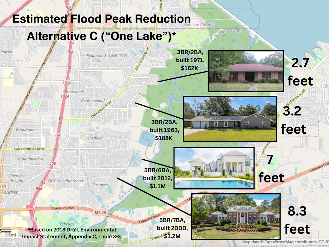
Highest flood peak reduction |
8.3 feet |
4.8 feet |
Adverse Impacts of Alt C ("One Lake")

- Hazardous Toxic Waste Sites on City of Jackson property: 8 dangerous waste sites are located in the proposed project area including 3 identified as major sites of concern. 1. Gulf States Creosoting Company Site (hatched red in NE corner of map): 141-acre site operated as wood treating facility for 25 years. The DEIS states that the creosote residuals occurring in the sediment cover a broad area and **that the creosote sloughs "present a continuing source of release of creosote chemicals to the environment and to the City of Jackson's drinking water." 2. Jefferson Street Landfill (hatched black on west side of river): 45-acre plot of land where City of Jackson operated an unregulated landfill dating back to early 1900s. Site Assessments have found Polynuclear Aromatic Hydrocarbons and benzene concentrations above regulatory limits. 3. Gallatin Street Dump Site (hatched black farther south): 117-acre site operated as unpermitted City of Jackson municipal dump for 20 years. Groundwater samples collected from borings placed within the landfill found leachate with concentrations of cadmium, lead, and nickel which were well above regulatory standards. Visual inspection showed leachate from the landfill seeping out of the soils along the bank of the Pearl River. View more HTRW details here.
- Hazards associated with removal of waste sites: The One Lake’s extensive dredging will re-suspend contaminated sediments and expose people, fish and wildlife to high levels of toxins. The 2018 DEIS states that the environmental impacts associated with their removal could include, “the temporary addition of large additions of sediment to the Pearl River, the release or exacerbation of current releases of leachate and/or solid and hazardous substances to the groundwater and/or surface water...”
- City drinking water supply: "Other immediate effects that may result from construction of the proposed project could include a temporary loss of the secondary water supply intake for the City of Jackson. Jackson utilizes an existing water treatment plant which is located on the Pearl River at a location scheduled for dredging and development of the “Channel Improvement/Weir/Levee” alternative. The dredging of sediments and subsurface soils in the Pearl River could potentially increase the turbidity of the surface waters to levels unacceptable for human consumption; therefore, the City of Jackson would need to evaluate temporary water supply alternatives during the duration of dredging and construction activities." (AllenES Environmental Evaluation of Hazardous, Toxic and Radiological Waste (HTRW) Sites, Sept 2014, p.16)
|
- Increased flash flooding in Jackson neighborhoods: The proposed elevation of the water that would be pooled at the new Alt C "One Lake" weir is 258’ or 8 feet higher than the water level of the current weir at Jackson Waterworks (250’). According to the 2018 DEIS (Appendix C, pages 32-36), the new impoundment water level of 258’ will increase the flood profiles along all 8 Jackson tributaries. The City of Jackson storm drain and tributary channel system is currently not capable of efficiently managing stormwater flash flooding. Heavy rains often cause Lynch Creek to overtop its banks, flooding neighborhood streets, businesses and homes. Due to the deterioration of century-old sewer infrastructure, this stormwater typically contains raw sewage and other contaminants. **The current flash flooding events in these Jackson neighborhoods will not be helped by the One Lake project and will instead be exacerbated as the storm drain runoff is slowed down by the backed-up tributaries.
 2024 USACE DEIS, PDF page 112, LeFleurs Bluff State Park
- Loss of public lands: 63 acres of LeFleur’s Bluff State Park, Jackson's only public access to the Pearl River and a popular recreation location, would be dredged away and permanently under water, according to the map published in the 2024 USACE DEIS. "One Lake" dredging would also dramatically alter the hydrology of Mayes Lake, a heavily used fishing and camping location within the park, and its hardwood forests and cypress brakes. Socioeconomic losses would be incurred by the destruction of a portion of the LeFleur’s Bluff State Park recreational resource.
- Harm to endangered and threatened species: Gulf sturgeon (Acipenser oxyrhynchus desotoi) is listed on both the federal and state threatened species lists. This species conducts yearly migrations that will be impacted by further impoundments on the Pearl River. Current USFWS project discussions underway to remove the sills at Poole’s Bluff will allow for increased Gulf sturgeon migration upriver to the project area. In spring 2021, a Gulf sturgeon, originally tagged by a USFWS Baton Rouge team in 2017, was detected in the Pearl River One Lake project area near LeFleurs Bluff State Park above the Jackson Waterworks weir by a tag reader from a University of Southern Mississippi Gulf sturgeon telemetry study. The ringed map turtle (Graptemys oculifera) and Pearl River map turtle (Graptemys pearlensis) are endemic to the Pearl River system and found nowhere else in the world. They use the Pearl's sandbars for laying eggs, and its logs for basking and feeding areas. The ringed map turtle is listed as threatened under the Endangered Species Act. According to FWS, “if the proposed reservoir is completed, it would likely result in the extirpation (extinction) of the known ringed map turtle population (south of the current reservoir)."
- Increased costs to Pearl River businesses holding discharge permits: Nearly 100 discharge permits have been issued in Mississippi downstream from Jackson and 8 in Louisiana. Businesses such as International Paper, Georgia-Pacific and our municipal sewage treatment plants rely on stable freshwater flow from the Pearl for adequate dilution and permit compliance.
|
- Induced Flooding: "...Alternative C would induce flooding on approximately 220 structures within the study area and potentially more structures south of the study area." 2024 USACE DEIS, PDF p 156. "The model showed additional flooding downstream for Alternative C, caused by an increase in stage to areas that were not flooded in the without project condition at both the 20 percent and 1 percent AEP. These inducements for the 20 percent AEP event appear to resolve just prior to the Copiah Creek confluence, approximately 32 miles downstream of the project." 2024 USACE DEIS, PDF p 194.
|
Pearl Riverkeeper asks that everyone make his or her own decision regarding the "One Lake" project (Alternative C) using sound science and engineering. We encourage the review and thorough analysis of all available information. We welcome comments and feedback. Please email Pearl Riverkeeper or visit our Facebook for comment space. Our publishing, or re-publishing, of anyone else's research or opinions is not an endorsement on our part of those conclusions.


